Uttarakhand Tourism | Uttarakhand Map
About Uttarakhand:
Uttarakhand, the 27th state of the Republic of India, is called "the abode of the Gods". It contains glaciers, snow-clad mountains, valley of flowers, skiing slopes and dense forests, and many shrines and places of pilgrimage. Char-dhams, the four most sacred and revered Hindu temples: Badrinath, Kedarnath, Gangotri and Yamunotri are nestled in the Himalayas. Haridwar which means Gateway to God is the only place on the plains.
It holds the watershed for Gangetic River System spanning 300 km from Satluj in the west to Kali river in the east. Nanda Devi (25640 Ft) is the second highest peak in India after Kanchenjunga (28160 Ft). Dunagiri, Neelkanth, Chaukhamba, Panchachuli, Trisul are other peaks above 23000 Ft. It is considered the abode of Devtas, Yakashyas, Kinners, Fairies and Sages.It boasts of some old hill-stations developed during British era like Mussoorie, Almora and Nainital.
Geography of Uttarakhand:
Uttarakhand has a total geographic area of 51,125 km², of which 93% is mountainous and 64% is covered by forest. Most of the northern parts of the state are part of Greater Himalaya ranges, covered by the high Himalayan peaks and glaciers, while the lower foothills were densely forested till denuded by the British log merchants and later, after independence, by forest contractors. Recent efforts in reforestation, however, have been successful in restoring the situation to some extent. The unique Himalayan ecosystem plays host to a large number of animals (including bharal, snow leopards, leopards and tigers), plants and rare herbs. Two of India's mightiest rivers, the Ganges and the Yamuna take birth in the glaciers of Uttarakhand, and are fed by myriad lakes, glacial melts and streams in the region.
Uttarakhand Weather:
Tourism in Uttarakhand:
Jim Corbett National Park:
Jim Corbett National Park—named after the hunter and conservationist Jim Corbett who played a key role in its establishment—is the oldest national park in India.The park was established in 1936 as Hailey National Park. Situated in Nainital district of Uttarakhand the park acts as a protected area for the critically endangered Bengal tiger of India, the secure survival of which is the main objective of Project Tiger, an Indian wildlife protection initiative.
The park has sub-Himalayan belt geographical and ecological characteristics. An ecotourism destination, it contains 488 different species of plants and a diverse variety of fauna. The increase in tourist activities, among other problems, continues to present a serious challenge to the park's ecological balance.
Corbett has been a haunt for tourists and wildlife lovers for a long time. Tourism activity is only allowed in selected areas of Corbett Tiger Reserve so that people get an opportunity to see its splendid landscape and the diverse wildlife. In recent years the number of people coming here has increased dramatically. Presently, every season more than 70,000 visitors come to the park from India and other countries.
The Jim Corbett National Park is a haven for the adventure seekers and wildlife adventure lovers alike. Corbett National Park is India's first national park which comprises 520.8 km2. area of hills, riverine belts, marshy depressions, grass lands and large lake. The elevation ranges from 1,300 feet to 4,000 feet. Winter nights in Corbett national park are cold but the days are bright and sunny. It rains from July to September.
Dense moist deciduous forest mainly consists of sal, haldu, pipal, rohini and mango trees, and these trees cover almost 73 per cent of the park. The 10 per cent of the area consists of grasslands.It houses around 110 tree species, 50 species of mammals, 580 bird species and 25 reptile species. The endangered Bengal tiger of India resides here. The sanctuary was the first to come under Project Tiger initiative.
Nainital:
Nainital is a town in the Indian state of Uttarakhand and headquarters of Nainital district in the Kumaon foothills of the outer Himalayas. Situated at an altitude of 1,938 metres (6,358 feet) above sea level, Nainital is set in a valley containing a pear-shaped lake, approximately two miles in circumference, and surrounded by mountains, of which the highest are Naina (2,615 m (8,579 ft)) on the north, Deopatha (2,438 m (7,999 ft)) on the west, and Ayarpatha (2,278 m (7,474 ft)) on the south. From the tops of the higher peaks, "magnificent views can be obtained of the vast plain to the south, or of the mass of tangled ridges lying north, bounded by the great snowy range which forms the central axis of the Himalayas."
Mussoorie:
Mussoorie is a city and a municipal board in the Dehradun District of the northern Indian state of Uttarakhand. It is located about 35 km from the state capital of Dehradun and 290 km north from the national capital of New Delhi. This hill station, situated in the foothills of the Garhwal Himalayan ranges, is also known as the Queen of the Hills. The adjoining town of Landour, which includes a military cantonment, is considered part of 'greater Mussoorie', as are the townships of Barlowganj and Jharipani.
Being at an average altitude of 1,880 metres (6,170 ft), Mussoorie,with its green hills and varied flora and fauna, is a fascinating hill resort. Commanding snow ranges to the north-east, and glittering views of the Doon Valley and Shiwalik ranges in the south, the town was once said to present a 'fairyland' atmosphere to tourists. The highest point is Lal Tibba with a height of over 2,290 metres (7,510 ft)
Almora:
Almora is a municipal board, a cantonment town in the Almora district in the state of Uttarakhand, India. Almora was founded in 1568.
It is a town bustling with activity and a rich cultural heritage and history. It is considered the cultural heart of the Kumaon region of Uttarakhand.
Kausani:
Kausani is a destination for Himalayan tourists. It is located 53km North of Almora. The altitude of this place is about 1890 mts. This place offers a 350 km view of the Himalayan peaks like Trisul, Nanda Devi and Panchchuli. There are very few places in the Himalayas which can compare with the beauty of Kausani - a picturesque hill station famous for its scenic splendor and its spectacular 300 km-wide panoramic view of the Himalayas. Kausani lies on the atop the ridge amidst dense Pine trees overlooking Someshwar valley on one side and Garur and Baijnath Katyuri valley on the other on Almora-Bageshwar-Didihat Highway. Mahatma Gandhi called this place the 'Switzerland of India', due to similarity in landscape.
Bhimtal:
Bhimtal is a town and a nagar panchayat in Nainital district in the state of Uttarakhand, India, situated at an altitude of 1370 meters above sea level and is about 22 kilometers from Nainital. The major attraction in Bhimtal is the Bhimtal Lake, which has an island at its centre. Besides tourism, Bhimtal has also now become a mini district headquarters since most of the district administration offices have been shifted to the newly constructed Vikas Bhawan, the building complex for district administrative offices.
Ranikhet:
Ranikhet is a hill station and cantonment town in Almora district in the Indian state of Uttarakhand. It is the home for the Military Hospital, Kumaon Regiment (KRC) & Naga Regiment and is maintained by the Indian Army.
Ranikhet is at an altitude of 1869 metres above sea level and within sight of the western peaks of the Himalayas.
Nanda Devi:
Nanda Devi is the second highest mountain in India (excluding Pakistan occupied Kashmir) and the highest entirely within the country (Kangchenjunga being on the border of India and Nepal); owing to this geography it was the highest known mountain in the world until computations on Dhaulagiri by western surveyors in1808. It was also the highest mountain in India before Sikkim joined the Indian Union. It is part of the Garhwal Himalayas, and is located in the state of Uttarakhand, between the Rishiganga valley on the west and the Goriganga valley on the east. Its name means Bliss-Giving Goddess.The peak is regarded as the patron-goddess of the Uttarakhand Himalaya.
Valley of Flowers National Park:
Valley of Flowers National Park is an Indian national park, Nestled high in West Himalaya, is renowned for its meadows of endemic alpine flowers and outstanding natural beauty. It is located in Uttarakhand state. This richly diverse area is also home to rare and endangered animals, including the Asiatic black bear, snow leopard, brown bear and blue sheep. The gentle landscape of the Valley of Flowers National Park complements the rugged mountain wilderness of Nanda Devi National Park to the east. Together they encompass a unique transition zone between the mountain ranges of the Zanskar and Great Himalaya. The park stretches over an expanse of 87.50 km². Both parks are encompassed in the Nanda Devi Biosphere Reserve (223,674 ha) which is further surrounded by a buffer zone (5,148.57 km²).This Reserve is in the UNESCO World Network of Biosphere Reserves since 2004.

The Valley of Flowers is an outstandingly beautiful high-altitude Himalayan valley that has been acknowledged as such by renowned mountaineers and botanists in literature for over a century and in Hindu religion for much longer. Its ‘gentle’ landscape, breathtakingly beautiful meadows of alpine flowers and ease of access complement the rugged, mountain wilderness for which the inner basin of Nanda Devi National Park is renowned.
Valley of flower is splashed with colour as it bloomed with hundreds different beautiful flowers, taking on various shades of colours as time progressed. Valley was declared a national park in 1982, and now it is a World Heritage Site. The locals, of course, always knew of the existence of the valley, and believed that it was inhabited by fairies.
While trekking towards valley of flowers, one can experience the beauty of shining peaks fully covered with snow. One can also see the beautiful view of surrounding greenery and various running streams with crystal clear water.
The valley is home to many celebrated flowers like the Brahmakamal, the Blue Poppy and the Cobra Lily. It is a much sought after haunt for flower-lovers, botanists and of course trekkers, for whom a sufficient excuse to embark on a mission to reach a place, is that it exists.

The Valley of Flowers is internationally important on account of its diverse alpine flora, representative of the Western Himalayan alpine shrub and meadows ecoregion. The rich diversity of species reflects the valley’s location within a transition zone between the Zaskar and Great Himalayas ranges to the north and south, respectively, and between the Eastern Himalaya and Western Himalaya flora. A number of plant species are internationally threatened, several have not been recorded from elsewhere in Uttarakhand and two have not been recorded in Nanda Devi National Park. The diversity of threatened species of medicinal plants is higher than has been recorded in other Indian Himalayan protected areas. The entire Nanda Devi Biosphere Reserve lies within the Western Himalayas Endemic Bird Area (EBA). Seven restricted-range bird species are endemic to this part of the EBA.
The Valley of Flowers was declared a national park in 1982. This part of Uttarakhand, in the upper reaches of Garhwal, is inaccessible through much of the year. The area lies on the Zanskar range of the Himalayas with the highest point in the national park being Gauri Parbat at 6,719 m above sea level.
Nanda Devi National Park:
The Nanda Devi National Park is a national park situated around the peak of Nanda Devi, 7,817 m (25,646 ft), in the state of Uttarakhand in northern India. It was established as national park in 1982. Along with the adjoining Valley of Flowers National Park to the northwest, it was inscribed a World Heritage Site by UNESCO in 1988. It covers 630.33 km² Both parks are encompassed in the Nanda Devi Biosphere Reserve (223,674 ha) which is further surrounded by a buffer zone (5,148.57 km²).This Reserve is in the UNESCO World Network of Biosphere Reserves since 2004.
The park encompasses the Nanda Devi Sanctuary, a glacial basin surrounded by a ring of peaks between 6,000 metres (19,700 ft) and 7,500 m (24,600 ft) high, and drained by the Rishi Ganga through the Rishi Ganga Gorge, a steep, almost impassable defile. The entire park lies at an elevation of more than 3,500 m (11,500 ft) above mean sea level.
CharDham:
Char Dham is an important Hindu pilgrimage circuit in the Indian Himalayas. Located in the Garhwal region of the state of Uttarakhand(formerly the northwestern section of Uttar Pradesh), the circuit consists of four sites—Yamunotri, Gangotri, Kedarnath , and Badrinath. Badrinath is also one of the four destinations (with each destination being in different corners of the country) of the longer Char Dham from which the Chota Char Dham likely draws its name.
While each of these sites is unique in its own fashion, inclusion in the Char Dham has, over time, caused them be viewed together in popular imagination and in pilgrimage practice.
Haridwar:
Haridwar is an important pilgrimage city and municipality in the Haridwar district of Uttarakhand, India. The River Ganges, after flowing for 253 kilometres (157 mi) from its source at Gaumukh at the edge of the Gangotri Glacier, enters the Indo-Gangetic Plains of North India for the first time at Haridwar,which gave the city its ancient name, Gangadwára.
Haridwar is regarded as one of the seven holiest places to Hindus. According to the Samudra manthan,Haridwar along with Ujjain, Nasik and Allahabad is one of four sites where drops of Amrit, the elixir of immortality, accidentally spilled over from the pitcher while being carried by the celestial bird Garuda. This is manifested in the Kumbha Mela being celebrated every 3 years in one of the 4 places, and thus every 12 years in Haridwar. Amidst the Kumbha Mela, millions of pilgrims, devotees, and tourists congregate in Haridwar to perform ritualistic bathing on the banks of the river Ganges to wash away their sins to attain Moksha. Brahma Kund, the spot where the Amrit fell, is located at Har ki Pauri (literally, "footsteps of the Lord") and is considered to be the most sacred ghat of Haridwar.
Haridwar is the headquarters and the largest city of the district. Today, the city is developing beyond its religious importance, with the fast developing industrial estate of State Industrial Development Corporation of Uttarakhand (SIDCUL), and the close by township of Bharat Heavy Electricals Limited in Ranipur, Uttarakhand as well as its affiliated ancillaries.
Rishikesh:
Rishikesh, also spelled Hrishikesh, Rushikesh or Hrushikesh, is a city and a municipal board in Dehradun district in the Indian state of Uttarakhand. It is surrounded by two other districts namely Tehri Garhwal and Pauri Garhwal. It is located in the foothills of the Himalaya in northern India and attracts thousands of pilgrims and tourists each year, from within India, as well as from other countries. Rishikesh is a vegetarian city by law, as well as an alcohol-free city. Rishikesh has also banned use of plastics bags by shopkeepers and vendors.
It is also known as the gateway to the Himalayas and is located around 25 kilometres north of another holy city, Haridwar.
Hemkund:
Hemkunt Sahib or Hemkund Sahib is a pilgrimage site for Sikhs in Chamoli district, Uttarakhand, India. With a setting of a glacial lake surrounded by seven mountain peaks and each peak is adorned by a Nishan Sahib on its cliff, it is located in the Himalayas at an elevation of 15,200 ft as per the Survey of India. It is accessible only by foot from Gobindghat on the Rishikesh-Badrinath highway.
Hemkunt Sahib is famous for the Sikh worship-place Gurudwara, known as Gurudwara Sri Hemkunt Sahib Ji, devoted to Guru Gobind Singh Ji (1666–1708), the tenth Sikh Guru, which finds mention in Dasam Granth, a piece of work narrated by Guru Gobind Singh Ji,Himself. The lake also has a Lakhmana hut on its shore which was later built into proper small shrine by the Sikhs.
How to Reach Uttarakhand:
Air:
Uttarakhand (Uttaranchal) has its only airport in Jolly Grant, which is close to the state capital Dehradun. Nearly all public and private airlines operate regular flights to Dehradun.
Road:
Although Uttarakhand (Uttaranchal) is a very young state in India, an extensive road network covers the state. Uttarakhand (Uttaranchal) has excellent road connection with Delhi and state highways link the destinations and important places like Corbett National Park, Haridwar, Rishikesh of the state to each other.
Rail:
Rail network is also very convenient in Uttarakhand (Uttaranchal). The keys Railway Stations in Uttarakhand (Uttaranchal) are Dehradun, Haridwar and Kathgodam. Many super-fast express and passenger trains service these stations.
Uttarakhand Map:
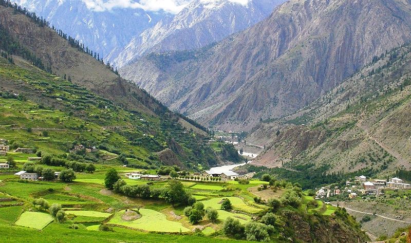
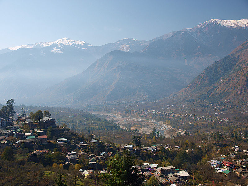
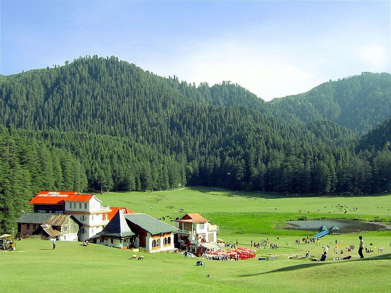
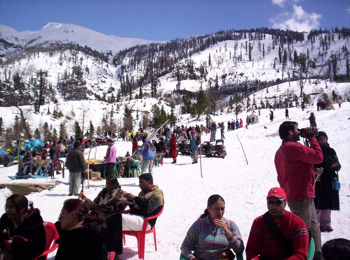
Pictures of Uttarakhand:
Uttarakhand Tourism,Uttarakhand Map,Geography of Uttarakhand,Uttarakhand Weather,Tourism in Uttarakhand,Pictures of Uttarakhand,Uttarakhand Transport