Showing posts with label Best time to visit. Show all posts

Mount Abu Tourism | Hotels in Mount Abu Rajasthan

Mount Abu Tourism |Hotels in Mount Abu


About Mount Abu :

Mount Abu About is the highest peak in the Aravalli Range of Rajasthan state in western India. It is located in Sirohi district. Mount Abu is 58 km from Palanpur (Gujarat). The mountain forms a distinct rocky plateau 22 km long by 9 km wide. The highest peak on the mountain is Guru Shikhar, at 1722 meters above sea level. It is referred to as 'an oasis in the desert', as its heights are home to rivers, lakes, waterfalls and evergreen forests. The ancient name of Mount Abu is "Arbudaanchal"

History of Mount Abu :


The Gurjars and Arbuda Mountain:


The Arbuda Mountains (Mount Abu) region is said to be original abode of the famous Gurjaras.The association of the Gurjars with the mountain is noticed in many inscriptions and epigraphs including Tilakamanjari of Dhanpala.These Gurjars (Gujars or Gujjars) migrated from Arbuda mountain region and as early as sixth century A.D, they set up one or more principalities in Rajasthan and Gujarat. Almost all or a larger part of Rajasthan and Gujarat had been known as Gurjaratra (country ruled or protected by the Gurjars) or Gurjarabhumi (land of the Gurjars) for centuries prior to Mughal period.

Mythology:


In the Puranas, the region has been referred to as Arbudaranya,("forest of Arbhu") and 'Abu' is a dimunitive of this ancient name. It is believed that sage Vasishtha retired to the southern spur at Mount Abu following his differences with sage Vishvamitra.

Climate of Mount Abu :


Mount Abu's has a pleasent climate thanks to its rich dense green forest cover, In summers when typical temperature of desertious Rajasthan is around 44°C , Mount Abu's temperature is 31°C to 34°C. In winters the temperature ranges from 10°C to -8°C (in Night) , Mount Abu receives the highest amount of rainfall in Rajasthan, average Rainfall during monsoon is 70-180 cm, It is advised to visit Mount Abu during rainy season in August-September to enjoy the monsoon and nature at its best to enjoy waterfalls, lush green mountains and the romantic mist.

Weather of Mount Abu :


In Summer: 33.8 C (Max) - 23.3 C (Min)
In winter: 20.3 C (Max) - 0 C (Min)
Rainy Season : from July to Mid Sept, and very humid (Upton 90%)

Places to Visit in Mount Abu:


Dilwara Temples:


The Jain Dilwara temples of India are located about 2½ kilometers from Mount Abu, Rajasthan's only hill station. These temples built by Chalukya between the 11th and 13th centuries AD are world famous for their stunning use of marble. The five legendary marble temples of Dilwara are a sacred pilgrimage place of the Jains. Some consider them to be one of the most beautiful Jain pilgrimage sites in the world. The marble temples have an opulent entranceway, the simplicity in architecture reflecting Jain values like honesty and frugality. The temples are in the midst of a range of forested hills. A high wall shrouds the temple complex.

Although the Jains built some beautiful temples at other places in Rajasthan, some believe that none come close to these in terms of architectural perfection. The ornamental detail spreading over the minutely carved ceilings, doorways, pillars and panels is simply marvellous.

For the people who come to perform puja here, there are facilities to bathe and get ready. The facilities use passive solar power to heat up the water for bathing and other things. Guided tour hours for tourists are posted outside the temple. You might see occasional monkeys looking for food outside the temple area.


Achalgarh Fort:


Achalgarh is a fort situated eleven kilometers north of Mount Abu, a hill station in Rajasthan, India. The fort was originally built by the Paramara dynasty rulers and later reconstructed, renovated and named as Achalgarh by Maharana Kumbha in 1452 CE,one of the several forts built during his reign.

The fort is not in good condition now. The first gate of the fort is known as Hanumanpol, which served as the entrance to the lower fort. It comprises two towers built of large blocks of grey granite. After some ascent, stands Champapol, the second gate of the fort, which served as the entrance to the inner fort.

There are some features of historical and religious importance in and around the fort. Achaleshwar Mahadeva temple is just outside the fort; the toe of Lord Shiva is worshipped there and a brass Nandi is also located there. Near the temple there are three stone buffaloes standing around a pond. There are Jain temples in the fort. These were built in 1513 CE.


Nakki Lake:


Nakki Lake is an Artificial lake situated in the Indian hill station of Mount Abu in Aravalli range.

It is a very ancient sacred Lake, according to the Hindu legend. It is called by this name because it was dug out from Nails (Nakh). One story is of dug by Gods to live in, for protection against the Bashkali rakshash (a wicked demon). While other is of Rasiya Balam (a sculpture of Dilwara Jain temple) , who dug the lake, as the king told that whoever will dug the lake within one night I will marry my daughter to him. But later king's wife refused and he couldn't marry the king's daughter. Temple of Rasiya Balam and Kunwari Kanya (king's daughter)'s is located behind the Dilwara Jain temple.

The lake is in length of about a half mile and in width about of a quarter of mile and 20 to 30 ft. deep towards the dam on the west. It is an important tourist attraction of Mount Abu. There is the Toad Rock on a hill near the lake. Toad rock is so called as it looks like a toad about to jump into the lake, from the side of the rock facing the lake. There are two ways to go up and down the rock; to climb the rocky hill side or to use the steps leading down to Nakki Lake. By the side of the lake there is a path leading to Sunset Point. It is forbidden to climb to Sunset Point due to dangerous bandits living around the path to Sunset Point. Raghunath Temple and Maharaja Jaipur Palace are also on hills near the Lake.

Boating in the lake and horse rides around the lake are available.


Guru Shikhar:


Guru Shikhar, a peak at an altitude of 5,676 feet (1722 meters), is the highest point in Rajasthan. It is located at a distance of 15 km from Mount Abu. It has a commanding view of Abu and its surroundings.
This peak is the home to the temple of Dattatreya, an incarnation of Lord Vishnu. There is a huge brass bell outside the shrine, which overlooks the lush greenery of Mount Abu.

Adjacent to the temple is the Mt Abu Observatory operated by the Physical Research Laboratory. This observatory hosts a 1.2m infrared telescope and also several aeronomy experiments.


Adhar Devi:


Situated in a cave, The Adhar Devi Temple is one of the popular religious themed tourist destinations in the Mount Abu region. It is situated three kilometers north of the main town of Mount Abu. The Adhar Devi Temple is reached by climbing up 365 stairs carved into the mountain. The temple itself is located inside a rocky cleave and is reached by crawling through a small opening into the cave.

The Adhar Devi Temple is dedicated to the Goddess Durga. It got its name because the legend has it that "Adhar" of the Mataji (Goddess deity) fell here also it was believed that the image of the goddess could be found there hanging in mid air. As well as being a popular tourist destination, the Adhar Devi Temple is also a common destination for many religion pilgrimages The Adhar Devi temple receives most pilgrims during the 9 days of the holy Navratri season.

The Adhar Devi temple contains many beautiful statues, and those that make the effort to climb the stairs are rewarded with many picturesque views of the surrounding mountains and forests. The climb up to the Adhar Devi temple can be a difficult one so it is recommended that you wear appropriate clothing and footwear. You should not be turned off by this walk as the scenic views surrounding the temple and the wondrous beauty inside make this climb worth the effort.


Sunset Point:


Of the various points around the town, Sunset Point, 1.5 km from the tourist office of Mount Abu, is the most popular. Hoards stroll out here every evening to catch the setting sun, the food stalls and all the usual entertainment. Is is a one kilometer walk from the road to the viewpoint or you can hire a horse.


Honeymoon Point:


Honeymoon Point, 2.5 kms northwest on Ganesh Road, also known as Andra Point, offers an enchanting view of the verdant plains and valleys. The place looks most beautiful during the dusk hours. The route to Honeymoon Point goes past the Nakki Lake.

Brahma Kumaris Museum:


Located south of the Nakki Lake you could spend some time partaking spiritual knowledge and understanding the tenets of the Brahma Kumaris. Also enjoy a laser show which helps in the methods of meditations.

How to Reach :


By Air:

Udaipur is the nearest airport. Daily flight form Delhi, Mumbai and Jaipur are available to Udaipur.

By Bus:

Rajasthan Roadways run very comfortable deluxe buses from Jaipur and Abu Road to Mount Abu. It is also connected by road to Delhi, Udaipur, Ajmer, Bundi and Udaipur.

By Train:

Abu Road is the nearest railway station and is about 22 kms from Mount Abu. And well connected by Ahmedabad, Jaipur, Mumbai and Jodhpur.

 Best Time to Visit:


The natural beauty and the lovely landscapes of mount Abu invite tourists throughout the year. Though Mount Abu is the perfect retreat in the summer months for the people from the plains and the deserts. This leads to increase in tariffs in all the hotels, restaurants and transportation charges. All hotels in Mount Abu are available at half rates and the best of rooms can be yours for a rate that suits your budget during winters though.

Hotels in Mount Abu:


Budget Hotels in Mount Abu:

Hotel Meera
Hotel Panghat
Hotel Shanti
Hotel Banjara
Hotel Ranjanas
Hotel Swagat
Hotel ParashNew
Hotel Lake view

4Star Hotels in Mount Abu:

Cama Rajputana Club Resort
Palace Hotel- Bikaner House
Palanpur Palace, Mount Abu
Hotel Ratan Villas, Mount Abu

3Star Hotels in Mount Abu:

Hotel Hilltone
The Jaipur House
HG Grandiose Hotel
Hotel Chacha Inn,
Kesar Bhawan palace


Pictures of Mount abu :


Mount Abu Tourism,Hotels in Mount Abu,4Star Hotels in Mount Abu,3Star Hotels in Mount Abu,Budget Hotels in Mount Abu,Best Time to Visit,How to Reach,Places to Visit in Mount Abu,Weather of Mount Abu and much more

Nainital Tourism | Nainital Hotels

Nainital Tourism | Nainital Hotels


About Nainital:


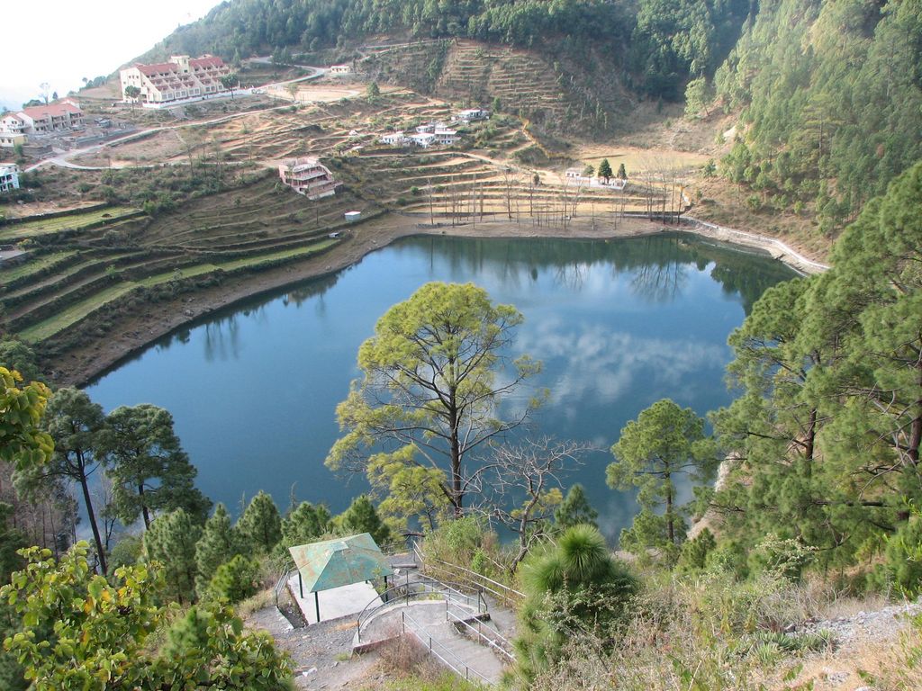
Nainital is a town in the Indian state of Uttarakhand and headquarters of Nainital district in the Kumaon foothills of the outer Himalayas. Situated at an altitude of 1,938 metres (6,358 feet) above sea level, Nainital is set in a valley containing a pear-shaped lake, approximately two miles in circumference, and surrounded by mountains, of which the highest are Naina (2,615 m (8,579 ft)) on the north, Deopatha (2,438 m (7,999 ft)) on the west, and Ayarpatha (2,278 m (7,474 ft)) on the south. From the tops of the higher peaks, "magnificent views can be obtained of the vast plain to the south, or of the mass of tangled ridges lying north, bounded by the great snowy range which forms the central axis of the Himalayas."

History of Nainital:


According to a legend Parwati the daughter of King Daksha held a great 'Yajna' but did not invite Parvati and her consort Shiva. Parvati could not bear this direct insult, in her great fury Parvati gate-crashed into the 'Yajna' ground and leaped into the high flames of 'Yajna' fire to end her life.And later lord Shiva retrieved her half-charred corpse himself. The majority of the local people believe that the eyes of Sati dropped in the lake while her body was being carried by Lord Shiva to Kailesh Parvat. Hence,the lake was given the name of 'Nainital' or Naini lake. Later the spot became famous by this very name.

Nainital (Recent history):

Nainital was founded in the year 1841 by Mr. P. Barron, a European merchant and an enthusiastic hunter from Rosa, near Shahjahanpur. Mr.P.Barron was the first European who took great fancy to this land. Moved by the beauty of the sparkling lake he wrote: "It is by far the best site I have witnessed in the course of a 1,500 miles treak in the Himalayas." It is very less is known about the history of Nainital. This region was called Khasdesh in ancient times and Khasis ruled this region before Christ was born. The name "NAINI" is derived from a temple to the goddess 'Naini Devi" built on the upper edge of the lake and was destoyed by the landslip of 1880. It was subsequently replaced by a modern structure. The word "Naini" means 'Eyes'and 'Tal' means 'Lake'.


Geography of Nainital:


Nainital is located at 29.38°N 79.45°E.It has an average elevation of 2,084 metres (6,837 feet).

Climate of Nainital:


As of the 2001 Indian census,Nainital had a population of 38,559. Males constitute 54% of the population and females 46%. Nainital has an average literacy rate of 91%, higher than the national average of 59.5%: male literacy is 98%, and female literacy is 86%. In Nainital, 1% of the population is under 6 years of age. Kumaonies form the major part of the town's population along with people from all over India.


Places to visit in Nainital:


Naina Devi Temple:

The Naina Devi Temple was destroyed by the landslip of 1880 and later rebuilt. It is located on the northern shore of Naini Lake. The presiding deity of the temple is Maa Naina Devi represented by two Netras or eyes. Flanking Naina Devi are the deities of Mata Kali and Lord Ganesha.

church of St.John:

The church of St. John in the Wilderness was established in 1844 and is located on the north end of town (Mallital), about half a mile north-west of the Naina Devi temple. The church was so named by Daniel Wilson, the Bishop of Calcutta, who, after falling ill during a visit to Nainital in 1844 to lay the foundation of the church, was obliged to sleep in an unfinished house on the edge of the forest. (See excerpt from Josiah Bateman on the Literary references to Nainital page.) A brass plaque on the altar is inscribed with names of the victims of the Landslip of 1880.

Governor’s House:

Governor’s House also known Raj Bhavan and formerly, Government House was built in 1899 and designed in the Victorian Gothic domestic style (also called "domestic Gothic") by the architect F.W. Stevens. Originally built as the summer residence of the governor of the North West Province, it later became the summer residence for the Lieutenant Governor of the United Provinces. Currently, Raj Bhavan is the official guest house for the governor of Uttarakhand and for visiting state guests. The complex consists of a two-storied mansion with 113 rooms, a large garden, a swimming pool, and golf links. Obtaining prior permission is must for visiting.

Snow View:

Snow View is situated at an altitude of 2,270 m (7,448 ft) and located atop the Sher-ka-danda Ridge (north by north-east of the town centre), is easily reachable by cable car.Charges for cable car is Rs. 100 per person, Rs. 60 for child. Charges are for stay for one hour at the point. Timings are 10.00a.m. to 5.00p.m. On a clear day, it offers spectacular views of the snowbound high Himalaya, including Nanda Devi, Trisul, and Nanda Kot. The best time of the year for viewing the mountains is late October and November.

Naina Peak:

Naina Peak also known as China or Cheena Peak. Naina peak is the highest peak in the town, with an altitude of 2,615 m (8,579 ft). and at a walking distance of 6 km (4 mi) from the north end of the town (Mallital). From atop the peak, one can not only see a broad swath of the snow clad high Himalaya, but also obtain a panoramic view of Nainital town itself. The summit is an invigorating hike from Nainital town; in addition, for the less energetic visitors, ponies can be hired in Mallital or on Snow View.

Tiffin Top:

Tiffin Top also known as Dorothy's Seat (Tiffin = light meal eaten during the day). This terraced hill top (2,292 m (7,520 ft)) on Ayarpatta hill is a 4 km (2 mi) hike from the town centre and commands a nice view of the neighbouring country side. Dorothy's Seat is a stonework picnic perch on Tiffin Top built as a memorial to an English artist, Dorothy Kellet, by her husband and admirers after her death in a plane crash.

High Court of Uttarakhand:

The High Court of Uttarakhand formerly known as The Old Secretariat. Mukteshwar (2,286 m (7,500 ft)) is a picturesque town 52 km (32 mi) north-east of Nainital, is home to the Indian Veterinary Research InstitutBhimtal Lakee. It also offers an unhindered view of the high mountains of the western Himalaya, including Nanda Devi, Trisul, and Nanda Kot.

Bhimtal Lake:

Bhimtal Lake is named after the second Pandava brother Bhima in the Mahabharata who was known for his prodigious strength. The lake, which is larger than Naini Lake, is approximately 22 km (14 mi) from Nainital at an altitude of 1,370 m (4,495 ft). There is an island in the lake with a popular restaurant on it. There is also a 17th century temple complex, the Bhimeshwar, alongside a 40 ft (12 m) high dam at one end of the lake.

Sattal:

Sattal, literally Seven Lakes, is at a distance of about 23 km (14 mi) from Nainital in the Lower Himalayan Range at an altitude of 1,370 m (4,495 ft). It is a cluster of small interconnected lakes in the midst of an old oak forest. On approaching Sattal, the first lake encountered is the Nal-Damyanti Lake; next it is the Panna or Garude lake; and finally there is a cluster of three lakes: Ram, Laxman, and Sita lakes.

Khurpa Tal:

Khurpa Tal, literally Trowel Lake, is an attractive lake about 10 km (6 mi) by road (or a 5 km (3 mi) hike) from Nainital at an altitude of 1,635 m (5,364 ft). It is popular with anglers and is surrounded by terraced fields (or farms), from which it presumably gets its name.

Naukuchia Tal:

Naukuchia Tal, literally, Nine-Cornered Lake, is 26 km (16 mi) from Nainital and 4 km from Bhimtal at an altitude of 1,220 m (4,003 ft). The lake is almost 1 km (1 mi) long, 0.5 km (0.3 mi) wide and approximately 40 m (131 ft) deep. It is the deepest of the lakes in the greater Naintal area. According to legend, if one takes in all nine corners in one glimpse, one can disappear in a cloud of smoke.

Hanumangarhi:

Hanumangarhi, also known as Hanuman Garh, is located at an altitude 1,951 m (6,401 ft). The temple complex is about 3.5 km (2.2 mi) from the Tallital (South End) bus stop. The presiding deity of the temple is Lord Hanuman, the vanara god of the Ramayana, and he is depicted tearing open his chest to reveal Rama and Sita in his heart. Hanuman Garhi is also known for its spectacular views of the setting sun. Ranikhet is a hill station and cantonment town in Almora district.


Jim Corbett National Park:


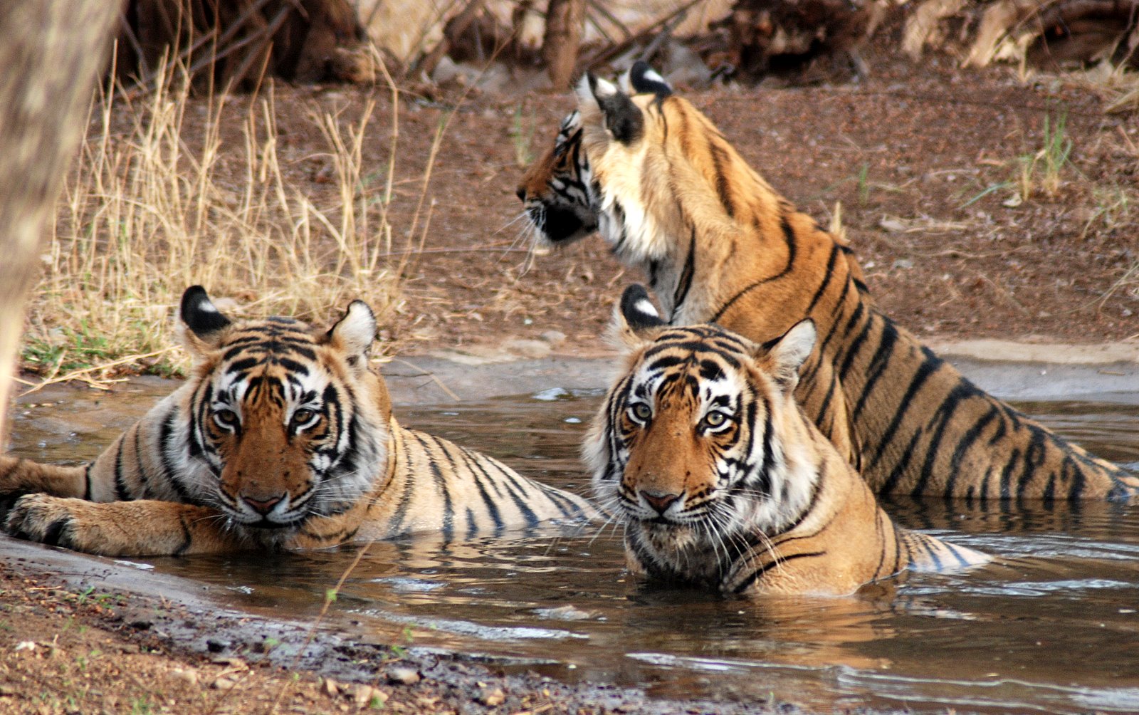
Jim Corbett National Park—named after the hunter and conservationist Jim Corbett who played a key role in its establishment—is the oldest national park in India.The park was established in 1936 as Hailey National Park. Situated in Nainital district of Uttarakhand the park acts as a protected area for the critically endangered Bengal tiger of India, the secure survival of which is the main objective of Project Tiger, an Indian wildlife protection initiative.

The park has sub-Himalayan belt geographical and ecological characteristics. An ecotourism destination, it contains 488 different species of plants and a diverse variety of fauna. The increase in tourist activities, among other problems, continues to present a serious challenge to the park's ecological balance.

Corbett has been a haunt for tourists and wildlife lovers for a long time. Tourism activity is only allowed in selected areas of Corbett Tiger Reserve so that people get an opportunity to see its splendid landscape and the diverse wildlife. In recent years the number of people coming here has increased dramatically. Presently, every season more than 70,000 visitors come to the park from India and other countries.

The Jim Corbett National Park is a haven for the adventure seekers and wildlife adventure lovers alike. Corbett National Park is India's first national park which comprises 520.8 km2. area of hills, riverine belts, marshy depressions, grass lands and large lake. The elevation ranges from 1,300 feet to 4,000 feet. Winter nights in Corbett national park are cold but the days are bright and sunny. It rains from July to September.

Dense moist deciduous forest mainly consists of sal, haldu, pipal, rohini and mango trees, and these trees cover almost 73 per cent of the park. The 10 per cent of the area consists of grasslands.It houses around 110 tree species, 50 species of mammals, 580 bird species and 25 reptile species. The endangered Bengal tiger of India resides here. The sanctuary was the first to come under Project Tiger initiative.


Best Time To Visit Nainital:


March - June and September - December.

How to Reach Nainital:


By Air:

Nainital does not possess an airport of its own. The nearest airport from the hill resort is that of Pantnagar, approximately 70 km away. The domestic airport at Pantnagar has regular flights from the capital city of Delhi. However, since the place does not have too great a connectivity, it is better to board a flight to Delhi and from there, undertake a road or rail journey to Nainital.

By Rail:

Nainital is conveniently accessible by different parts of the country, mainly due to the presence of a well-laid rail network. The nearest railway station to the hill station is Kathgodam, about 35 km away from the main town. New Delhi, Lucknow and Kolkatta are well linked with Kathgodam through regular trains. The next nearest station is Lalkuan, located at a distance of 60 km from the main city of Nainital.

By Road:

The most feasible way to reach Nainital is via road. The extensive road network that connects Nainital with several other parts of northern India makes road travel cheaper and more convenient. New Delhi is about 310 km away from Nainital and it hardly takes eight hours to cover the distance. Many private tour operators provide luxury bus services, including Volvos, between the hill station and other cities of northern India. The state government also operates several buses, connecting Nainital with other cities of Uttarakhand and northern India.

Nainital Hotels:


Best Budget Hotels in Nainital:

Hotel Vikrant
Hotel Anamika
Kamp Land Nature Resort
Emerald Trail, Janglia Gaon
Hotel Maharaja
Palace Hotel
Hotel Sunrise
Hotel Sea Hawk inn
Bob's Place

2 Star Hotels in Nainital:

Relax inn Kathgodam,Zayka
The Pavillion, Nainital
Rewa Retreat
Silent Villa
Hotel Krishna
Hotel Radha Continental

3 Star Hotels in Nainital:

Alka - The Lakeside Hotel
The Earl's Court, Nainital
Maya Regency Bhimtal
Eden Garden Star Resorts
Balrampur House
Hotel Himalaya

4 Star Hotels in Nainital:
Country Inn Bhimtal
Shervani Hilltop
Arif Castles
Vikram Vintage Inn
The Manu Maharani

Nainital Photos:


Nainital map:


Nainital Tourism,Nainital Hotels,About Nainital,History of Nainital,Geography of Nainital,Places to visit in Nainital,Climate of Nainital,Jim Corbett National Park,How to Reach Nainital,best time to visit,Budget Hotels in Nainital,Nainital Photos,Nainital map and much more